Friday, March 20, 2009
Week Five: Bring on Mud Season and Sunny Skies
Sunrise over wildcat and the peaks to the southeast of the summit. One of many great sunrises we had this week. In the morning instead of my ritual shovelling, I would run out in my slippers and fleece to get some shots of the colors. The nice, still weather allowed for very little blowing snow and hardly any precipitation --a welcome thing, although it did get me a little less exercise this week.
The weather this week wasn't particularly interesting, but certainly beautiful. After a day of freezing rain, we had high pressure, sunny weather through the rest of our time up. This made for several sunrises and sunsets, and some great stars as well. We didn't really get out to watch the stars as a group this time, but we had several overnight trips that were happy to see them. The winds from the west and northwest also created some fantastic lenticular clouds off of the summit cone, including one that persisted for several days on and off. These were especially nice in the pink and orange light of the sunrise. The high pressure systems also made the air very stable, creating a visible boundary layer on the horizon. This was pretty significant to me, since I've been studying the movement of this layer.
I went hiking with Brian (my first time hiking with him) to the summit of Monroe, which is just above Lakes of the Clouds. I'd never summited it before, and it was definitely worth the somewhat painful climb straight up the side. We had some really great food this week thanks to our volunteers, Sue & Mike Zlogar. Mike gave me some recipes for one of our family traditions, Potica, and also for sourdough pancakes.
Between meals, I also managed to get some more work done on my research --I started running the Stability Time Series model for all summer days for the study years to find average boundary layer heights for each year and month. I also looked more into using the particle dispersion model rather than the simple trajectory to find the source of the pollutants, and started preparing for those runs. This data is going to be difficult to deal with because there will be more of it, and it will need to be organized quite differently in order to be interpreted. I found out earlier this week that, despite my small contribution to the paper, I'm going to be a co-author in the first of Georgia's articles on this PM work. Very cool!!
Back down off the mountain, we felt rain as soon as we got out of the cat. It was refreshing to feel the familiar little drops falling on my face, and it's nice to once again see running waterways and trees. The week of warm weather has brought the "mud season" on earlier than the local obs people would expect, but I'm happy to see it come. I enjoyed a little puddle stomping and sitting by the creek at the base before we went out for a visit to a sugar shack. Chris of the State Park up on the summit built his own little sugar shack (for distilling maple syrup), and has been running for the past few days. The place smells amazing, and he showed me around the machinery a bit.
The river in front of our house is also flowing nicely, and provides a constant swish and humm when you're anywhere near the windows. With the sun shining and the water running, the conditions are perfect for a good run and a little guitar playing.
Tip Top House (the oldest remaining building on the summit), the top of the obs tower, and the summit sign
The North Presidentials and Nelson Crag Trail sign from the front entrance of the building, taken around sunrise. The mountains pictured are Adams (left) and Madison (right).
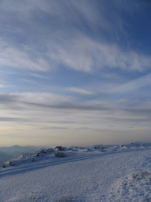
Whispy low cirrus (maybe?) over the summit, looking ESE. Also taken at sunrise.
An undercast sunrise, looking over Wildcat mountain.
The top of the Tuckerman Ravine Trail, which leads down the summit cone on the southeast side to the Lion's Head Trail and Tuckerman Ravine. Tuck's is a pretty famous spot for skiing and hiking, mostly, as I understand, because of its classic bowl shape.
This is a piece of the electrical cord that brings us our power. It was put in a bit over a year ago. You can see the huge amount of copper that's in it, and all the insulation. The wire runs about three miles along the Cog Railroad tracks, and seems to have survived so far. We've been out of power once while I've been up here, which just means we have to switch to using the kerosene generators that were previously used fulltime.
Stairs leading down the Tuckerman Ravine Trail top. Closed for the winter, but nice to look at in the snow.
On Wednesday morning, Marty decided to venture outside. He went up on his own, which hasn't happened since I've been here. He has been out before in the winter, but doesn't usually like the snow on his paws. This time, he roamed around for a few minutes and tried to clmb up the southwest side of the obs deck, which has ice-covered rocks all up it, but slid all the way down again with only his little claws to keep him in place. I must say, despite his lack of skillz in the snow, he does look nice.
Here's a shot of his not-so-successful climb up the icy rocks. Apparently the presence of a hiker scared him into the climb, and the whole thing made for some interesting and awkward shots of him...
Another good thing about a calm week: no shovelling! I barely had to shovel at all. The ice on the obs deck never actually came off --there was a good little chunk of it up there the whole week. As for this pain-in-the-neck emergency exit, however --I shovelled it once.
The melting left some great patterns in the rime ice as well. This shot is a bit after sunrise, looking over the southeast side of the obs deck.
This is the Pitot tube, which measures wind speed at the top of the tower. It's usually used on airplanes, but in this case, as Brian says, "the wind blows through us rather than it blowing through the wind." (He does shows over the video equipment every few days in which he explains all the weather equipment and such.) The Pitot is heated, but it still gets clogged up when we have particularly icy and windy conditions. This means we have to go pump out the tubes that connect to it in the tower, and "de-ice" it (hit the post holding it up with a crow-bar) every hour or so.
A shot of the North Presis, but this time with the distinct boundary layer in the background.
A mountain shadow just before sunset --the mountain is big enough to actually cause a shadow to form from our perspective. Pretty cool, and this one was very distinct because of the cloudless conditions.
Looking southward down to Monroe (the point peak). This is where Brian and I hiked to this week --the photo was taken the following morning. You can also see the Lakes of the Clouds hut if you look close enough, at the base of the Monroe summit cone on the right.
This isn't the best picture ever of them, but here are Mike and Sue Zlogar of Amhurst, Mass., our cooks for the week. They were very successful in corned beef and cabbage, as well as big breakfasts every morning and some delicious-looking desserts.
A self portrait against the North Presis, taken from the top of the tower.
Another of Marty scrambling on up the side of the obs deck.
Looking upward from the base of the obs deck to the tower on the south side. Very little snow after a week of spring weather!
This was a very interesting lenticular that stayed for over 24 hours this week. I think you can almost see the shape of the summit in it --the winds from the west and northwest caused it to form. It would dissipate, then half would appear, or it would get little whispies along the top --really neat to see it evolve and change.
Some more lenticulars hanging off to the west of the summit. This was at sunrise --possibly the first we saw this week.
Jim of State Park, walking over to Yankee Building to check on the equipment and building temperature, etc. The State people do this twice a day. Jim's a really nice guy, and has been working at the summit since last November. Favorite movies: Gold Member and Harold & Kumar Go to White Castle.
This is my little intern corner, where it all happens. It's really nice to have two extra large screens to work with, and the system is really fast. We also have plenty of toys around (you can see the reindeer up on the light base), and the observers and I frequently throw the little plastic lizards and other items at each other to keep from falling asleep during the day.
A photo of the North Presis, with icicles and glaze ice chunks on the base of the tower deck in the foreground.
Footsteps in the nicely coated snow. You can see that people don't sink in far, and there's a bit of a crunch when you walk. In a lot of places, especially on hills, it's pretty much impossible to walk without crampons.
This is the top of Crawford Path, part of the Appalachian Trail. It's what we took down to Monroe, and it also goes down to the Lakes of the Clouds. As I think I mentioned in an earlier blog, it's the oldest maintained trail like this in the country.
This is Brian, who thinks he looks cool in his "blades" and Penn State hat. He thinks.
Brian slinging out on the obs deck. They have to do it in the shade for continuity --the temperature of the instrument needs to consistently measured either in the shade or sun so that the ambient temperature isn't altered by that change. They generally walk around a bit after slinging to see the cloud cover and estimate visibility.
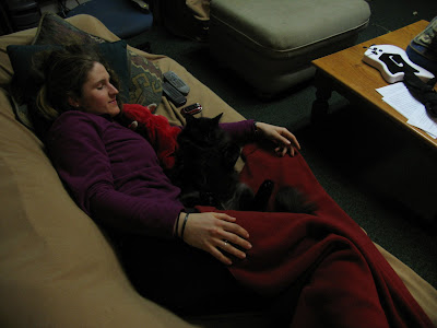
Brian sleeping with the kitty in the observer office. This is really unusual to see, as the cat doesn't really cuddle. Brian, however, is a napper.
Here's a good shot of the boundary layer and some serious haze right around us. This pic is looking WNW toward Bretton Woods ski area on the left, and the foothills of the N Presis on the right.
Here's the spout for the AIRMAP (monitored air pollutants up until this year, when funding ran out) project. You can also see the boundary layer on the horizon, off to the west. The intake here is on the tower.
Some hikers coming up the Tuckerman Ravine Trail, with the top of Tuck's in the background to the left. You can also see Attitash and Bear Peak in the back (the first place I ever skiied!) and the Mount Washington Valley to the left-center there.
Here's "Whitey". She's our new snow cat, complete with DVD player and cushy, individual seats. She's been having some issues lately, but we always root for having her come up instead of the "Short Bus." Not that we don't love the Short Bus, but we prefer to have Scrubs to keep us occupied on the hour+ trip down.
This is the Sttate Park and rotunda side of the building from the fron entrance. That pain-in-the-neck emergency exit that I shovel is at the bottom of the building on the left where all the ruffled snow is. Off to the right are the N Presis.
A shot of the sunset from the tower. This one was a bit too cloudy to see much, but still quite beautiful. It's been a bit of a ritual to come up and watch it with Mike and the volunteers --hopefully there will be many more in the next few weeks.
And last but not least, a nice shot of me bugging Ryan. I wrote a comment this week about what I do while I'm on the summit, and had Brian take this shot to include. Ryan's face is priceless. I know he was truly annoyed with me for having it taken, but he did an excellent acting job nonetheless.
Saturday, March 7, 2009
MWO Specials
Here's a list of some of the recipes that I've been gathering from our fantastic volunteers. I hope that they don't mind that I'm sharing these... We're having some excellent meals up at the summit while I'm up thanks to these dedicated, hardworking people. They've also been great friends to have around --to chat with, get cooking advice and back scratches from, and also go on hikes with. Thank you, volunteers, and to everyone else --try these!!
Janet Standley at the summit sign
Pumpkin Pie by Janet Standley (week four)
1 10" pie crust
1/2 cup sugar
1 Tbsp flour
1/2 tsp salt
1 tsp ginger
1/2 tsp cinnamon
1/8 tsp nutmeg
1 1/2 cups pumpkin*
1/2 cup dark Karo syrup
2 eggs
1 cup milk
Combine sugar, flour, salt and spices. Add pumpkin and Karo syrup. Beat eggs and add along with milk. Pour into pie shell. Bake at 450 for 10 minutes, then 350 for 30 minutes. (Can also bake in 1 1/2 quart casserole dish, set in pan of hot water.)
*can also use 1 can of pumpkin
Windigo Meat Loaf by Janet Standley (week four)
2 1/2 lbs ground meat
5 pieces bread, finely chopped
1 large onion, chopped
2 large green peppers, chopped
3 large carrots, chopped
2 eggs
1 cup ketchup
salt and pepper
1 can whole crannberry sauce
Grease casserole dish. Place cranberry sauce on bottom of dish. Mix all other ingredients and place in dish. Bake 350-400 for 45 minutes or until done.
Anadama Bread by Janet Standley (week four)
(This recipe is 100 years old!)
Makes two loaves
1/2 cup yellow cornmeal
2 Tbsp shortening
2 cups boiling water
1 tsp salt
1/2 cup molasses
1 package yeast, dissolved in 1/2 cup luke warm water
5 cups white flour
Stir cornmeal slowly into boiling water and let steam very slowly over a double boiler (use two pot setup) for an hour (1/2 hour is ok). Add shortening, molasses, and salt. Cool. When luke warm, add yeast dissolved in the warm water. Add enough flour to make a regular stiff dough. Turn out and knead for ten minutes (be good and rough with it!). Place in a greased bowl and let rise to more than double in size (plastic wrap over the top seems to work better than a warm towel). Shape and place in two bread pans (steel or glass works better than aluminum). Let rise until light (not quite double). Bake at 400 for 1/2 hour. Remove from pans immediately.
Pork Stew by Bob Foudriat (week four)
2 lbs pork chops, boned and chunked
Pepper to taste
Pressed garlic to taste (about 1 head)
2 medium onions
2 bags shredded carrots
2 celery sticks, chopped
2 bottles beer (lighter, such as a pilsner is good)
1 container beef broth, low sodium
2 Tbsp Emeril's cajun seasoning or similar
Salt to taste
Brown pork, season with pepper and garlic. Add in onions and carrots, allow to stew. Add in celery and beer. Add broth and other seasonings to taste, allow to cook.
Joan's Hearty Pancakes by Janet Standley (week four)
Makes pancakes for two people
1 cup white flour
1 cup whole wheat flour
1 cup corn meal
1/2 tsp salt
3 Tbsp baking powder
Mix the above ingredients and keep in the fridge; use as needed.
3/4 cup dry ingredient mix (above)
1 egg
1 Tbsp oil
3/4 cup milk and yogurt (1:1; any flavor yogurt)
Don't overmix --leave some powder in the batter.
The Best Blueberry Muffins Janet Standley (week four)
Makes about 12 medium size
Beat together with a fork:
1 egg
1/2 cup milk
1/2 cup oil
In another bowl, mix together:
1 1/2 cups sifted flour
1/3 cup sugar
2 tsp baking powder
1/2 tsp salt
Add dry ingredients to liquid. Add 1 cup bluberries (can dredge in flour if not frozen). Bake at 375 for 20-25 minutes. Can add a mashed banana, or improvise.
Marcia's Cheese Ball by Winslow Dodge (week three)
12 oz cream cheese
1/3 cup Parmesan cheese
1/4 cup mayonnaise or miracle whip
1/2 tsp oregano
1/4 tsp garlic powder
Roll in walnuts or crumbs
The week three volunteers with the observers at the summit sign; from left: Win Dodge, Brian Clark, Mike Finnegan, Ryan Knapp, and John Bauhs
Apple Pie by Win Dodge (week three)
Pillsbury Golden Pie Crust (or any pie crust)
Fill bottom crust heaping full of apples (about eight apples per pie)
Mix in separate bowl and add:
1 c sugar
2 Tbsp flour
1/2 tsp cinnamon
Dot top of pie with butter and a few drops of lemon. Put a small amount of butter on the bottom layer of the crust and on top of the mix before putting on top layer of crust. Poke holes in top with knife, add more butter to the top. Seal pie well by moistening edges and tamping down with fingers and fork. Put pan beneath pie to catch drip. Bake one hour or so at 450 for first 15 minutes, and at 375 for remainder of time.
No Bake Cheesecake by John Bauhs (week three)
8 oz cream cheese
14 oz sweetened condensed milk
1/3 c lemon juice
1 tsp vanilla extract
Beat cheese until fluffy, mix in other ingredients. Pour into graham cracker crust.
Flourless Chocolate Cake by John Bauhs
8 oz butter
1 1/2 c chocolate chips
1 1/4 c sugar
1 c unsweetened cocoa powder
6 eggs
Melt butter and chocolate chips. Mix sugar and cocoa, add to melt. Beat eggs, combine all ingredients. Bake at 325 for 25-30 minutes.
Blueberry Pie by Win Dodge (week three)
Pillsbury Golden Pie Cruse (or any pie crust)
Fill bottom crust heaping full of blueberries.
Add:
1 cup sugar
2 Tbsp flour
A little lemon and butter
Dot top of pie with butter and a few drops of lemon. Put a small amount of butter on the bottom layer of the crust and on top of the mix before putting on top layer of crust. Poke holes in top with knife, add more butter to the top. Seal pie well by moistening edges and tamping down with fingers and fork. Put pan beneath pie to catch drip. Bake one hour or so at 450 for first 15 minutes, and at 375 for remainder of time.
Marion Lake on crampons in front of the stage office
Hermits by
Makes 2 dozen
1 cup sugar
½ cup shortening
2 beaten eggs
½ cup molasses
1 tsp each cinnamon and nutmeg
½ tsp each cloves (use allspice) and salt
1 tsp soda
2 ½ cups sifted flour
½ cup chopped walnuts or almonds (optional)
1 cup raisins
In a bowl, cream shortening and sugar. Add beaten eggs. Sift dry ingredients and add alternating with molasses. Fold in raisins and nuts. Grease 13” and 9” cookie sheet. Spoon batter into three long strips. It will spread out. Bake at 375o for 12 minutes. Do not over bake. Cut while warm from the oven.
Al Lake, week two, flying on top of the tower
Aleknagik Bread (Alaskan Molasses Bread) Made by Marion and Al Lake, recipe from Wood River Lodge (week two)
Makes 2 loaves of bread
This bread is an ideal base for the heartiest of sandwiches and is an excellent substitute for biscuits or rolls at the evening meal. This recipe was featured in the August 1999 issue of the
5 ½ to 5 ¾ cups all purpose flour
2 packages yeast
½ cup cornmeal
2 cups boiling water
½ cup dark molasses
1/3 cup shortening
1 tbsp salt
2 eggs
2 tbsp butter, melted
In a large mixing bowl, combine 3 cups of flour and yeast. Gradually (this step takes practice in order to avoid lumps in the cornmeal mixture. I have found using a whisk very helpful) stir cornmeal into boiling water; add molasses, shortening and salt. Cool to lukewarm. Combine cornmeal mixture and flour mixture; add two eggs. Mix until the mixture is uniformly lumpy. By hand, stir in enough of the remaining flour to make a soft dough. Knead until smooth and elastic (about 10 minutes).
Place in a lightly greased bowl, turning once to grease surface. Cover and let rise in a warm place until double (about 1 ½ to 2 hours).
Grease two 4 ½” x 8 ½” x 2 ½” loaf pans. Punch down the dough and divide in half.
Cover and let rest 10 minutes. Shape into 2 loaves and place in greased loaf pans. Cover and let rise until double (45 to 60 minutes).
Bake at 375o about 35 minutes. Brush warm bread tops with melted butter.
Shepherd's Pie, made by Marion & Al Lake
Quick Oatmeal Cookies from Joy of Cooking, made by
Makes about 3 dozen 2-inch cookies
Preheat oven to 350o
Measure:
½ cup brown sugar, firmly packed
½ cup granulated sugar
Cream with:
½ cup butter
Combine and beat in until smooth:
1 egg
1 tsp vanilla
1 tbsp milk
Sift together and add to the above ingredients:
1 cup all-purpose flour
½ tsp soda
½ tsp double-acting baking power
½ tsp salt
When beaten smooth, add:
1 cup uncooked quick rolled oats
¾ cup chocolate chips
1 tsp grated orange rind
Beat the mixture well. Drop cookies 2” apart on well-greased cookie sheet and bake until light brown.
Week Four
Some really nice clouds --you can't really see it here, but these are little curls over the top of mt. Jefferson. These are the same kind as the really well-defined K-H cloud that I saw on my second week up. They're formed by wind shear over the mountains.
Despite some of the worst weather the east coast has seen in a long time, this week on the mountain was pretty tame. Winds only reached about 85 mph and humidity was really low. I did the famous boiling water to snow experiment this week (thanks to some very excited German students), though, and saw some great sunsets. Saturday we took a really nice hike down to the Lakes of the Clouds, then back up past Tuckerman Ravine (Tuck's), and up the summit cone in less than 20 minutes (!!). The colors were really nice that day, with an undercast that burned off as the morning went on and a great ice crust for cramponing. The day before we'd gotten some freezing rain thanks to the first of two low pressure systems that came up the coast. The second low was the big one that hit the rest of the area on Monday, but we watched the edge of the cloud bank roll by to our east. All of the observers and myself also took the sleds out to a big hill on the east side of the summit for a couple of great rides on Saturday night. We watched a fantastic sunset on Saturday as well as Sunday, and enjoyed the good company of our friends over at State Park both nights as well. I got my first tour of the haunted building --Yankee-- on Saturday night. There were a few spooky parts of the building--creepy little bedrooms, but heavy duty radio equipment for the most part. Supposedly it's safe, but I may have permanently fried any hopes of having children.
Also this week, I started actually running some models for my research. Georgia (writing the paper) had me run a series of dates through a stability time series model, which outputs information related to the location of the atmospheric mixing layer. We found out that the diurnal patterns produced between the location of that layer and the agreement/disagreement between particulate matter concentrations at the higher and lower sites was pretty clear and conclusive. This was particularly exciting because of the numerous assumptions that the model was making, which were especially inaccurate for the uneven terrain we're looking at. There were still several things which don't make sense to me about the way that the data come out, and also about the variables that were outputted by the model, but I'm going to have a conversation with Georgia at some point this week.
For the future --I'm getting ready to accept a very exciting offer that I've had from the University of Portland Chemistry Department for this fall. The professors have been really helpful and the department very generous. I still get a term to officially decide on a research advisor, but there are two --now three professors in atmospheric chemistry who would be great to work with. So after NH, Portland here I come!
To top the week off, I went over to visit a friend of my aunt's in Porter, Maine Thursday through Saturday. Jackie and her husband Mike were really great to take me in for a couple days at their gorgeous farm house (my camera unfortunately is eating batteries like there's no tomorrow, so no pictures of that yet --although she invited me for anytime I want to go back!). They have: seventeen sheep (nine pregnant and about ready to burst), two horses, three llamas, sixteen chickens, three dogs (two boarder collies and a chow-looking mix), two cats, and 140 acres of beautiful Maine land. We snowshoed over to the beaver marsh on their property, past the babbling brook, through the woods full of Balsam Fir, White Pine, Birch, and Hemlock, and up over the hill with snowshoe hare prints. It was absolutely beautiful. Jackie made some fantastic quiche with eggs fresh from the hens, and I even got to try some of their lamb from last season (she doesn't eat meat, but Mike and I enjoyed it!). On Friday, I wanted to go for a run on the really nice road their house was on, and Mike suggested that I go the eight miles into Porter and back. Unbelievably, I did it!! I messed up my knee a bit on the very slanted edges of the road, but I think that's the farthest I've ever knowingly run in one go! Thank you high altitudde living! And, of course, thank you Mike and Jackie!!
The reason that we can't really play soccer in the rotunda... this is a painting of Lizzy Bourne, the first woman to die on Mt. Washington. It's an antique. I don't really understand why she's significant enough among the other figures in the history of the mountain to have a painting like this up in the rotunda during the winter, but there it is. A bit manly, but no doubt a very strong woman.
Janet Standley, one of our volunteers from the week, standing at the summit sign with the obs in the back to the WNW. Janet makes really, really good bread and jams. I stole some of her recipes.
View from the rotunda, looking south. The windows are mostly coated with plastic, but a few have been left open for viewing. This is a good window for sunrises.
I think that Marty had a good dose of catnip this week, because he was particularly friendly. He's never a lap cat, but he hopped right up when I was taking a Scrubs break on an especially frustrating day. You can see just how comfy he got.
Looking to the south toward Portland (ish). I think this was the beginning of the second low that came in --the one that brought the huge amount of snow for most of New England. We could see the side of it roll on by before we got some light snow and freezing fog for a while.
The view a bit further east, with Wildcat there on the left.
Chris of State Park with Michelle Cruz, who works at the Weather Discovery Center (WDC) in the valley. Michelle just got engaged!! I inspected the ring --a very nice pick. Congrats, Michelle!
Standing at the main entrance to the obs, with hikers in the background, waiting for the snow cat to head down. Gus, one of the cat drivers, is on the left, Mike (an observer and friend) is on the right, and Chris of State Park is in front of him.
Mike and Chris of State Park. Chris is a carpenter as well as a cat driver, ex-fisherman, sugarer (he distills maple syrup and built his own sugar shack --a really nice one) and he now works for MW State Park as one of the caretakers.
This is Marcell. This is a ridiculous picture of him. He's a master's student at the University of Ruhr in Germany, where some of the recent German bachelor's students are also from. Unlike the others, though, Marcell stayed on the mountain --without coming down-- for three weeks. He was a really funny guy, and I'm glad that we got to spend lots of time with him. Among other things, he's a drummer for a Metallica cover band and has a whole slew of pet rats. Definitely a character. He will be missed.
Sleepy Brian (fellow observer and friend) in the observer office.
Gus (August), the cat driver. He's also quite a character, and very bright. He thinks I'm a bit of a pest, but he's still friendly.
Freezing rain on the windows, looking northwest toward Mt. Clay
Rime ice with some freezing rain over the top
Overcast with cap clouds flooding over the north Presidentials
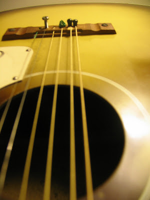
The summit guitar... As you can see, it's very make-shift. A great guitar player came up with a hiking group this week, and it took him about an hour and a half to try to tune the other guitar --then probably an hour to fix this one. The strings aren't exactly the same distance apart on this one, but at least it stays somewhat in tune for the good part of an hour. This one is wicked hard to play because it's so tight, but he managed to play beautifully all night --pretty much any song we wanted.
A quick video tour of the observatory, upstairs...
Here's the weather room, with all the instrument readings, the windows looking out to the north and west, and the observers' desk. This is where we spend almost all of our time during the day --doing forecasting, writing/communicating for/with certain media, etc., etc. It's on the second floor of the obs, along with the rotunda and the main entrance. The living quarters and kitchen are on the first floor.
Next a look around the observatory deck, where we take the observations on the hour, where hikers look around when they reach the top, and where everyone gathers to sight see in the summer. This video starts looking at the tower toward the west over the Southern Presidentials (and Franconia Notch, although you can't really see it--it's the snow-capped ridge over there). The Northern Presidentials are the ones to the north of the obs (Clay, Adams, Jefferson, Madison). The part of Mt. Washington that kind of juts out is called Ball Crag, and the curved lines in the snow beneath it are the Cog Railway (closest; only runs in the summer), and the Auto Road. As you come back around, you can see the A-Frame that keeps us from blowing away and ice from blowing on us when it's super windy, what's left of Rimey the snowman, the ceilometer (cloud-o-meter) shack, and the rest of the obs deck.
This one is of the trip up to the tower, through the staircases. The tower steps are kind of cool, partially because I feel a bit like a mad scientist going up them, and partially because the tower reminds me of the one in The Sword and the Stone. Slightly different magic at the top. The big, noisy machines in the glass case at the top of the first set of stairs are the AIRMAP project, which used to measure all kinds of pollutants --due to loss of funding, it's now down to CO and O3.
This last one is a view from the top of the tower steps, onto the tower deck, and around the 360 degree view from the tower. The door faces WSW, the north Presidential mountains are due north, the observation deck is ENE, the hikers are standing at the summit sign, you can see the rest of the summit buildings and radio towers, with the southern Presidentials in the background, and finally the instrument railing at the top of the tower. This is a great place to watch the sunset from and the red, railed-in part is really fun when the wind is blowing. The tower deck is also where I single-handedly removed about 4" of hard, glazed ice that covered the cement this past week. Took me about three hours, but wow was it good exercise --and it made dinner even better than usual.